Orchid spotting is a bit like detective work. Where else have I seen this? Which other locations are similar? Who else has seen anything? Is there a pattern to follow from last year? Are there any other obvious clues? Today was no exception
I had seen spider orchids on my bicycle rides in Ku-Ring Gai Chase NP. They were growing in a dry and sandy area of mixed sclerophyll forest about 200 metres above sea level. Maybe a bit more banksia than eucalyptus scrub. My friend had posted photos from similar locations. I had seen a photograph on an information board of the orchid on one of my visits to a picnic area. We had a weekend away in Hunter valley, where I have a house on a vineuyard. My wife was busily engaged in a social stitch and bitch event. Perfect time for me to get on the bicycle and head off to find that noticeboard.

The picnic area is in Werakata NP not very far from Cessnock in the Hunter Valley. The National Park was only proclaimed in 1999 following the amalgamation of several parcels of Cessnock State Forest. As such the area has been somewhat undisturbed other than logging for the surrounding coalfields and for road building - the convict built Great North road passes through the park. Nowadays it is just a gravel access road between East Cessnock and Maitland - and not a thoroughfare.
https://www.nationalparks.nsw.gov.au/visit-a-park/parks/werakata-national-park
Now I have looked for orchids here before without much luck. Maybe today was to be my day. I parked up the bicycle leaning against the noticeboeard which has photos of two orchids = one white and one pink. I take a few steps onto the grassy section of the picnic area and spy the telltale flash of colour standing about 3 inches (6 to 7 cms) above the ground. There are a few in this first spot visible from my parking spot.

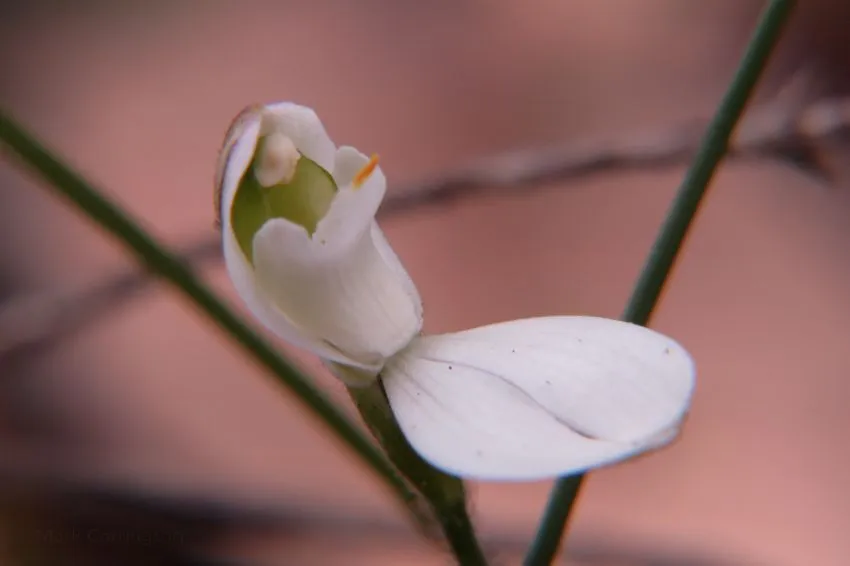
The English name for this orchid is pretty obvious - the flower has 5 white fingers.

What sets this orchid apart for me is the intricacy of the labellum and column.

Taken at f/8, 1/100 sec ISO-400.
The labellum folds forward and downwards and has a yellow tip. There are two rows of nodules (called calli) which arch forward towards the tip. The column then arches forward and over towards the point of the labellum.

White Fingers - Caladenia catenata
http://plantnet.rbgsyd.nsw.gov.au/cgi-bin/NSWfl.pl?page=nswfl&lvl=sp&name=Caladenia~catenata
Side on it looks to me like the arched neck of a white swan.

Taken at f/5.6, 1/125 sec ISO-400. This top down view shows the calli ruffles well

Photo work is quite challenging as the flower is quite large - the size of a bottle cap - and the petals spread quite widely making it challenging to get everything in focus. Light conditions were good which meant I could bring ISO down to 400 and most pictures were taken at full f/8 f-stop.

I found quite a few flowers where the lateral sepals are still joined together making for a quite different picture. I am guessing that in a few days those sepals will separate

And the side on swan look

This next picture shows how the column is quite fully developed yet the dorsal sepal (the white part that will stand erect behind the column) is still quite small.

and zoomed in
This picnic area is on the edge of what is called the Kurri Sand Swampland. The area is listed as an ENDANGERED ECOLOGICAL COMMUNITY. Kurri Sand Swamp Woodland generally ranges from low open-woodland to low woodland and open scrub. There is generally a low open canopy rarely exceeding 15 m in height, with Eucalyptus parramattensis subsp. decadens, Angophora bakeri and occasionally Eucalyptus signata and Eucalyptus sparsifolia. The shrubby stratum is typified by Melaleuca nodosa, Banksia spinulosa, Dillwynia retorta, Jacksonia scoparia, Hakea dactyloides, Acacia ulicifolia and Lambertia formosa and merges into the ground layer. The ground layer has grasses and low shrubs such as Entolasia stricta, Pimelea linifolia, Lissanthe strigosa and Melaleuca thymifolia. A considerable number of ground orchid species have been recorded in the area.
http://www.environment.nsw.gov.au/determinations/KurriSandSwampWoodlandSydneyEndComListing.htm
The environmental challenge is that the area has become fragmented and there are only pockets of certain unique plant species some of which may now only exist in seed form. I can vouch for how desolate the whole area looks after a few seasons of hot and dry weather. There was very little standing water in the swampy areas as one can see from the photo

The sandy base is also clearly visible where the fire trail has become extended.

The orchids themselves were only visible in a small area around the information board - maybe in a 100 square meter area (300 square yards). I did scour all the bush around for quite some distance in each direction. I never did find the pink flower shown on the information board. Next time. The map shows the National Park in green. My route is in red - out and back. I did continue past the picnic area and explore the fire trail roads beyond. The bush is quite a bit thicker here and not much growing in the under-story. The picnic area is the small nodule on the top side of the straight red line of my route.

Photos taken with Canon Powershot G16 on September 1, 2017.