
Hello dear Hivers!
Hola queridos amigos de Hive!
Today I want to share with you some of the wonders of nature that are found in this challenging route on the Ávila mountain: The ascent to the Western Peak and the walk through La Fila del Ávila (the ridge of the mountain) to reach the famous Humboldt Hotel (part of what is known as "La Travesía").
Hoy quiero compartir con ustedes algunas de las maravillas de la naturaleza que se encuentran en esta desafiante ruta en el cerro del Ávila: El ascenso al Pico Occidental y el paseo a través de La Fila del Ávila (la cresta de la montaña) hasta llegar al famoso hotel Humboldt (Parte de lo que se conoce como "La Travesía").

I have had the pleasure of doing this route 3 times. The first time with my boyfriend and the other two with him and a group of friends. The experience has always been incredibly satisfying and I am planning to do it again soon.
He tenido el placer de hacer esta ruta en 3 oportunidades. La primera vez con mi pareja y las otras dos junto a él y un grupo de amigos. La experiencia siempre ha sido increíblemente satisfactoria y estoy planeando volver a hacerla pronto.
All the photos I show you in this post were taken by me or 
Todas las fotografías que les muestro en este post fueron tomadas por mí o por

The route
La Ruta

The Avila Mountain has multiple hiking trails, which connect with each other. In the image above you can see only the main ones, since among them there are many other alternative paths made by expeditionists, which should be walked with a guide and a good map, as they can be misleading and take you to dangerous areas from which it is difficult to return.
El Cerro del Ávila tiene múltiples rutas de senderismo, las cuales conectan entre sí. En la imagen de arriba pueden ver apenas las principales, ya que entre ellas hay muchos otros caminos alternativos hechos por los expedicionistas, los cuales se deben transitar con un guía y un buen mapa, ya que pueden llegar a ser engañosos y llevarte a zonas peligrosas de las cuales es difícil regresar.

The black arrows on the map above show the route we took to make this trip. As you can see, it goes through all the difficulties, with the last stretch being quite demanding.
Las flechas negras del mapa superior señalan la ruta que tomamos para hacer este recorrido. Como pueden ver, pasa por todas las dificultades, siendo el último tramo bastante exigente.
R.S. Sabas Nieves
P.G.P. Sabas Nieves
Our route began in the Altamira urbanization to take the entrance to the mountain that leads us to the Sabas Nieves Park Ranger Station.
Nuestra ruta comenzó en la urbanización Altamira para tomar la entrada al Cerro que nos lleva al Puesto de Guarda Parques de Sabas Nieves.
This first part of the route is the least attractive, so we did not stop to take pictures. The road is barren, orange soil, and is usually crowded with people, as it is the preferred route for exercising in the mountains.
Este primer pedazo de la ruta es el menos atractivo, así que no nos detuvimos a tomar fotos. El camino es árido, de tierra naranja, y está por lo general atestado de gente, ya que es la ruta predilecta para ejercitarse en la montaña.

When you reach the Sabas Nieves Ranger Station, after about a 1300-meter walk, you find yourself in a large, flat area where people usually rest and eat, so we did the same.
Al llegar al Puesto de Guarda Parques de Sabas Nieves, tras unos 1300 metros de recorrido, te encuentras en una zona amplia y plana donde la gente suele descansar y comer, por lo que nosotros hicimos lo mismo.
Of course, most people retrace their steps after this break, while we were just beginning our trek up the hill.
Por supuesto, la mayoría de las personas vuelven tras sus pasos después de este descanso, mientras que nosotros apenas íbamos comenzando nuestra travesía cerro arriba.

While having breakfast there in Sabas Nieves we made a friend: this little bird of various colors known in Venezuela as the "Querrequerre" and internationally as the "Inca Jay".
Mientras desayunábamos ahí en Sabas Nieves hicimos un amigo: este pajarito de variados colores conocido en Venezuela como el "Querrequerre" e internacionalmente como el "Inca Jay".

Because of the constant flow of people, the little birds near this Park Ranger station have become very sociable, so we even had the wonderful experience of feeding our Qherrequerre directly to its little beak.
Por el constante flujo de gente, los pajaritos cercanos a esta estación de Guarda Parques se han vuelto muy sociables, por lo que incluso tuvimos la maravillosa experiencia de alimentar a nuestro Querrequerre directamente a su piquito.
Viewpoint "The little bench"
Mirador "El banquito"
With our tummies full, we resumed our journey, now heading to the viewpoint of "El banquito" (The little bench).
Ya con la pancita llena retomamos nuestro camino, ahora rumbo al mirador de "El banquito".

From this point the climb becomes much more interesting. You begin to enter a forested environment, there are more birds and butterflies, and the temperature starts to drop.
A partir de este punto la subida se vuelve mucho más interesante. Comienzas a internarte en un ambiente boscoso, hay más pájaros y mariposas, y la temperatura va descendiendo.


The trees in this area seem ideal for being home to fairies, elves and all sorts of magical creatures!
Los árboles de esta zona parecen ideales para ser el hogar de hadas, duendes y todo tipo de criaturas mágicas!

There are many species of beetles in the Avila. On this walk we met a beautiful specimen of Rhinoceros Beetle!
Hay muchas especies de escarabajos en el Ávila. En este paseo nos encontramos a un precioso espécimen de Escarabajo Rinoceronte!

We took it on a stick for the photo but then returned it to the bush in a safe place. ❤️
Lo tomamos en un palito para la foto pero luego lo regresamos al monte en un lugar seguro ❤️

We arrived at our next resting point: El Banquito viewpoint. Here is a mandatory stop to take pictures with the city landscape in the background.
Llegamos a nuestro siguiente punto de descanso: El mirador de El Banquito. Aquí es una parada obligatoria para tomarse fotos con el paisaje de la ciudad de fondo.

This viewpoint is located at 1600 meters above sea level.
Este mirador se encuentra a 1600 metros de altura.


A well-deserved rest and now to continue! On the way to the "Don't hurry" shelter.
Un merecido descanso y ahora ¡a continuar! Rumbo al refugio "No te apures".
"Don't Hurry" Shelter
Refugio "No te apures"
At this point on the mountain, wildflowers are already beginning to be seen.
A estas alturas de la montaña ya se comienzan a ver flores silvestres.

This particular one is known as the "Butterfly Bush". At the time we captured it in this photo the buds had not yet opened, but each of those purple twigs is getting ready with multiple tiny flowers!
Éste en particular se conoce como "Arbusto de las mariposas". En el momento en que lo capturamos en esta foto aún no se habían abierto los capullos, pero cada una de esas ramitas moradas se está preparando con múltiples pequeñas flores!

And you surely imagine what's near a butterfly bush... Butterflies, of course!
Y ya se imaginarán qué hay cerca de un Arbusto de las mariposas... ¡Por supuesto! ¡Mariposas!


We barely managed to capture this little one below before she flew away, but if you look closely you'll notice something wonderful: Her wings are transparent!
A esta pequeña de abajo apenas logramos capturarla antes de que se fuera volando, pero si se fijan se darán cuenta de algo maravilloso: ¡Sus alas son transparentes!

Her names is "Greta Oto", also known as "Glasswing butterfly".
Su nombre es "Greta Oto", también conocida como "Mariposa de cristal", o "Espejitos".

Now we arrived at "Don't hurry", at 1800 meters above sea level.
Ahora llegamos a "No te apures", a 1800 metros de altura.
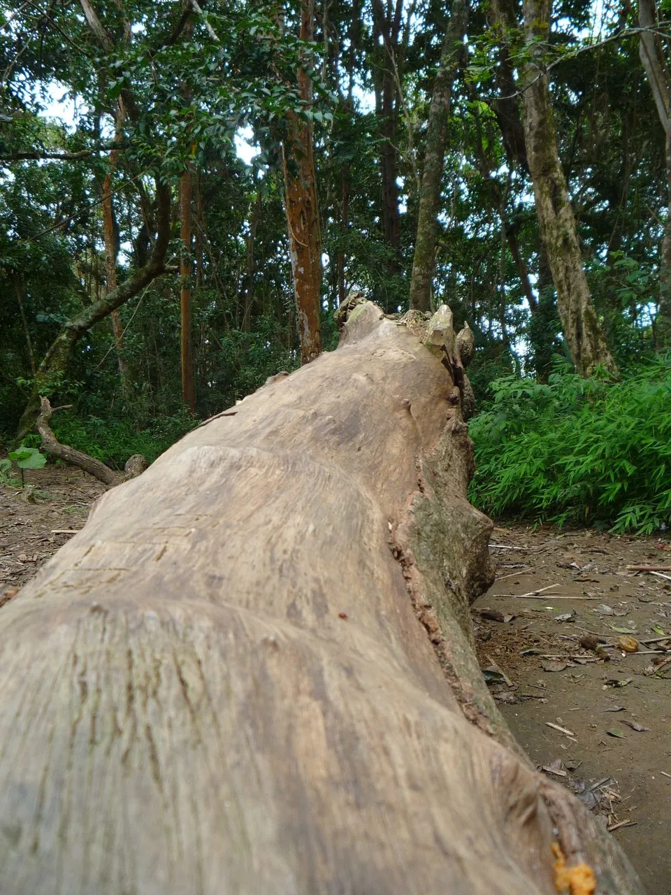
Around the refuge there are several fallen logs where one can sit to eat and rest.
Alrededor del refugio hay varios troncos caídos donde uno puede sentarse a comer y descansar.

At this point we always refill our bottles in a nearby creek and then we can continue our way to the western peak.
En este punto siempre recargamos nuestras botellas en una quebrada cercana y después sí podemos continuar nuestro camino hacia el pico occidental.
The Western Peak
El Pico Occidental

Here begins my favorite part. The trail from "Don't Hurry" to West Peak has very narrow paths, surrounded by dense brush and uneven terrain full of roots and rocks.
Aquí comienza mi parte favorita. El tramo desde "No te apures" hasta el Pico Occidental tiene caminos muy estrechos, rodeados de densa maleza y con un terreno irregular lleno de raíces y rocas.


The temperature drops noticeably, and this allows us to begin to see the " sub-moor" type vegetation, with a greater variety of flowers, plants with such strange shapes that they look like plastic, and even forest berries.
La temperatura desciende notablemente, y eso nos permite comenzar a ver la vegetación de tipo "sub-páramo", con una mayor variedad de flores, plantas con formitas tan raras que parecen de plástico, e incluso bayas de bosque.


At this point of the trip we have already surpassed 2000 meters above sea level. The mist begins to surround us, and the air, in addition to being cold, becomes very humid. You officially start to be "among the clouds".
En este punto del viaje ya hemos superado los 2000 metros sobre el nivel del mar. Nos comienza a rodear la neblina, y el aire, además de frío, se pone muy húmedo. Comienzas a estar oficialmente "entre las nubes".


Shortly before reaching the Western Peak there is an intersection called "The chair" where you can choose between going to the Western or Eastern peak. There we met this little fellow, an Indigo Bunting, apparently.
Poco antes de llegar al Pico Occidental hay una intersección llamada "La Silla" donde puedes escoger entre ir al pico Occidental o al Oriental. Allí nos encontramos a este amiguito, un Azulejo, al parecer.

And here you see me with "Morrigan", a female dog that accompanied us during the whole journey. She was always a little faster than us, even though she was limping on one hind leg!
Y aquí me ven junto a "Morrigan", una perrita que nos acompañó durante todo el recorrido. Siempre iba un poco más a prisa que nosotros, ¡Y eso que cojeaba de una patita trasera!

When you are almost reaching the peak, the whole path is very rocky, and instead of walking, it becomes more of a climbing terrain.
Cuando vas casi llegando al pico todo el camino es muy rocoso, y en lugar de ir caminando se vuelve más un terreno de escalada.
In the photo above you can see part of the steep rock path, and the beautiful scenery we were leaving behind.
En la foto de arriba pueden ver parte del empinado camino de rocas, y el hermoso paisaje que íbamos dejando atrás.

In this one you can see more berries on the left and in the background on the right the rock path.
En esta pueden ver más bayas a la izquierda y al fondo a la derecha el camino de rocas.

And after climbing for a while...
Y después de escalar un buen rato...

We reached the Western Peak!
¡Llegamos al Pico Occidental!


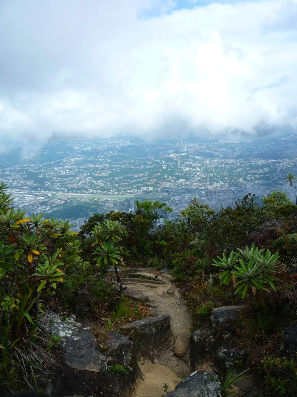
From there, if you are lucky and it is not too cloudy, you can see both sides of the mountain range. To the north the city of La Guaira and the sea (photo above), and to the south the city of Caracas (photo below).
Desde allí, si tienes suerte y no está demasiado nublado, puedes ver ambos lados de la cordillera montañosa. Al norte la ciudad de La Guaira y el Mar (Foto de arriba), y al sur la ciudad de Caracas (Foto de abajo).

Of course, at this point we always sit down for a while to celebrate our achievement, enjoy the beautiful scenery that nature provides and breathe plenty of fresh, unpolluted air.
Por supuesto, en este punto siempre nos sentamos un rato para celebrar nuestro logro, disfrutar del hermosísimo paisaje que nos brinda la naturaleza y respirar bastante aire fresco sin contaminación.


The third time I came, it was very breezy and cold at the Peak, so we had to hug each other to hold on to the place for a while before continuing.
En la tercera oportunidad que vine, en el Pico estaba haciendo mucha brisa y mucho frío, así que nos tocó abrazarnos para resistir un rato en el sitio antes de continuar.


Now take a last look at the scenery because we are going to the "Fila del Avila", the route along the entire ridge of the mountain towards the Hotel Humboldt.
Ahora echen un último vistazo a los paisajes porque nos vamos a la "Fila del Ávila", el recorrido por toda la cresta de la montaña hacia el Hotel Humboldt.


Our goal: The Humboldt Hotel (Year 2014. Currently restored and in operation).
Nuestro objetivo: El hotel Humboldt (Año 2014. actualmente se encuentra restaurado y en funcionamiento)

Fila del Ávila
Once you start descending from the Pico Occidental through the Fila del Avila you get a direct view of the Hotel Humboldt. It is the only point on the ground from where you can see this building from above, since it is located at 2155 meters above sea level.
Una vez comienzas a bajar del Pico Occidental a través de la Fila del Ávila obtienes una vista directa del Hotel Humboldt. Es el único punto de tierra firme desde donde se puede ver este edificio desde arriba, ya que dicha construcción se encuentra a 2155 metros sobre el nivel del mar.
The Fila del Ávila is a long route of descents and ascents along the mountain ridge. This path is very narrow and even dangerous, as there is only the steep mountainside on both sides.
La fila del Ávila es un largo recorrido de bajadas y subidas por la cresta de la montaña. Este camino es muy estrecho e incluso peligroso, ya que sólo se encuentra la empinada ladera de la montaña a ambos lados.


Here is a glimpse of the road from afar:
He aquí un vistazo al camino desde lejos:

Watch your steps!
¡Camina con cuidado!

After a steep descent we find ourselves in Lagunazo, a small stop where there is a pipe that collects the water flowing from the mountain. Bottles can be refilled and some groups stay here to camp.
Después de una pronunciada bajada nos encontramos en Lagunazo, una pequeña parada donde se encuentra una tubería que recoge el agua que fluye de la montaña. Se pueden recargar las botellas y algunos grupos se quedan a acampar.

I suspect we always get very tired at this point, because I don't have any more pictures of this place, hahaha. I will try to take some next time I go.
Sospecho que siempre llegamos muy cansados a este punto, porque no tengo más fotos de este lugar, jajajaj. Trataré de tomar algunas la próxima vez que vaya.

And we are coming to the end! The last part of the route is also a steep climb where you can't stop to take pictures.
¡Y ya vamos llegando al final! El último tramo de recorrido es una subida también bastante empinada en la cual no se pueden hacer paradas para tomar fotos.
The Humboldt Hotel
El Hotel Humboldt

At the end of the climb you meet directly with the hotel, connecting immediately with the tourist boulevard of the Avila, where we met Morrigan again.
Al terminar la subida te encuentras directamente con el hotel, conectando de inmediato con el bulevar turístico del Ávila, donde nos volvimos a encontrar a Morrigan.


And so this is the end, dear friends! In this boulevard we usually have a meal to recharge our batteries, and then we take the cable car down the mountain and go back home.
Y pues este es el final, queridos amigos! En este bulevar solemos comer para recargar energías, y después nos montamos en el teleférico para bajar de la montaña y volver a casa.


Byyyee!! See you next post!
Adioooos! Hasta el próximo post!
If you found this post entertaining or interesting please don't forget to Vote and Reblog 💞
Si les pareció entretenido o interesante este post por favor no olviden Votar y hacer Reblog 💞
Thanks for visiting Ni de Cabeza! Come back soon!
¡Gracias por visitar Ni de Cabeza! ¡Vuelve pronto!
🍀🦄🎢

Créditos - Credits
Flecha negra usada en el mapa - Black arrow used on the map
Escobita voladora / Flying broom - Vector de Dibujos animados creado por brgfx - www.freepik.es
Sombrero con cuaderno / Witch hat with book - Vector de Libro creado por brgfx - www.freepik.es
Castillo volador de firma / Signature flying castle - Imagen de my best in collections - see and press 👍🔖 en Pixabay
Traducción al inglés / English translation: DeepL versión gratuita