
English
Welcome to the magic of Argentina: walk with me through the Andes Mountains
A few days ago we went with a friend who has moved to Buenos Aires to the Mendoza mountains, a very traditional outing for both locals and tourists, especially for those who visit the city for the second or third time.
This area of Mendoza is very famous, I am referring to the mountain, since in the Andes Mountains is one of the highest mountains in the world: Mount Aconcagua, with almost 7000 meters above sea level.
It is a place visited by many climbers and mountaineers from all over the world who decide to challenge themselves and go ahead to climb that peak that seems to take people to the top of the world.
In my case, I am not a person who loves that kind of challenges, but I do love natural environments, and the Mendoza mountain has always fascinated me, so I took advantage of the fact that one of my best friends came to visit Mendoza from Buenos Aires (she moved a little more than a year ago), and as we both missed that landscape a lot, we took the opportunity to make a day trip.
Español
Bienvenidos a la magia argentina: pasea conmigo por la Cordillera de Los Andes
Hace unos días fuimos con una amiga que se ha ido a vivir a Buenos Aires a la montaña mendocina, una salida bastante tradicional tanto para locales como para turistas, sobre todos para quienes visitan la ciudad por segunda o tercera vez.
Este espacio de Mendoza es muy famoso, me refiero al de la montaña, ya que en la Cordillera de los Andes se encuentra uno de los cerros más altos del mundo: el cerro Aconcagua, con casi 7000 msnm de altura.
Se trata de un lugar visitado por muchísimos andinistas y alpinistas de todo el mundo que deciden desafiarse y darle para adelante al ascenso a esa cima que parece llevar a las personas a la cúspide del mundo.
En mi caso, no soy una persona demasiado amante de ese tipo de desafíos, pero sí amo los entornos naturales, y la montaña mendocina siempre me ha enamorado, así que aproveché que una de mis mejores amigas vino a visitar Mendoza desde Buenos Aires (se mudó hace un poco más de un año), y como las dos extrañábamos mucho ese paisaje, aprovechamos para hacer un viaje por el día.


La ruta de Cacheuta
We made some stops where the environment changed a lot, so today I will show you a part of this little trip. Otherwise, the publication would be reduced to an endless amount of images where each place would lose its magic. Although I could separate the trip in more publications to be clearer, I will do it only in two parts, which are the most marked from my point of view.
The first one, which is this one, will be focused on the route through Cacheuta until reaching the beginning of the Mendoza River from the Potrerillos Reservoir, and the other one will be the climb to a hill that we did that same day. Each moment has its magic, its history and its landscapes, and as I don't talk much about my province, now that I will bring you to ride with me almost in real time, I want to do it well.
The mountain route, already entered in the department of Luján de Cuyo, in my opinion is the most entertaining of the Argentinean routes that I have traveled, since it keeps you permanently alert by its curves but also offers a landscape that is changing permanently, so it is very difficult to get bored.
La ruta de Cacheuta
Hicimos algunas paradas en donde el entorno se modificaba bastante, por lo que hoy les mostraré una parte de este pequeño viaje. Caso contrario, la publicación se reduciría a una cantidad interminable de imágenes en done cada lugar perdería su magia. Aunque podría separar el viaje en más publicaciones para ser más clara, lo haré solamente en dos partes, que son las más marcadas desde mi punto de vista.
La primera que es esta, estará centrada en la ruta por Cacheuta hasta llegar al inici del Río Mendoza desde el Embalse Potrerillos, y la otra será la subida a un cerro que hicimos ese mismo día. Cada momento tiene su magia, su historia y sus paisajes, y como poco hablo de mi provincia, ahora que los traeré a pasear conmigo casi en tiempo real, pues lo quiero hacer bien.
La ruta de la montaña, ya ingresados en el departamento de Luján de Cuyo, a mi parecer es la más entretenida de las rutas argentinas que he transitado, ya que te manttiene permanentemente alerta por sus curvas pero además ofrece un paisaje que va cambiando de manera permanente, por lo que es muy difícil aburrirse.


As you go on, you enter more and more into the mountain, which first offers its foothills, and then leaves you immersed in high brown rocky walls with bushes as if dotted across the surface. It always reminded me of the movie "Jurassic Park", although clearly the vegetation has nothing to do with the one in that story, hehe.
To get to the Potrerillos reservoir there are two main roads: Route N°7 or the Cacheuta route. We took the other one because we wanted to see the famous tunnel that was finished about 5 years ago. We have already seen both of them, but it is always beautiful to see the scenery when you are coming out of the middle of the mountain.
Once we were in front of the dam in Cacheuta, we stopped the car and got out to enjoy the scenery before continuing on our way.
The hills were beautiful, it was around 9 am and the sun was still tender. At this time of the year it is already very hot at 11 am.
A medida que avanzas, vas entrando más y más a la montaña, que ofrece primero su precordillera, y luego te deja sumergida en altas paredes marrones rocosas con arbustos como salpicados por la superficie. Siempre me hizo acordar a la película “Parque Jurásico”, aunque claramente la vegetación no tiene nada que ver con la que hay en aquella historia, jeje.
Para llegar al embalse Potrerillos hay dos caminos principales: la Ruta N°7 o la ruta de Cacheuta. Tomamos esta otra porque queríamos ver el famoso túnel que se terminó de construir hace alrededor de 5 años. Las dos ya lo hemos visto, pero siempre es hermoso ver el paisaje cuando estás saliendo del medio de la montaña.
Una vez estuvimos frente al dique en Cacheuta, paramos el auto y nos bajamos a disfrutar del paisaje, antes de seguir camino.
Los cerros estaban bellísimos, era alrededor de las 9 de la mañana y el sol se sentía aun tierno. En esta época a las 11 am ya hace muchísimo calor.


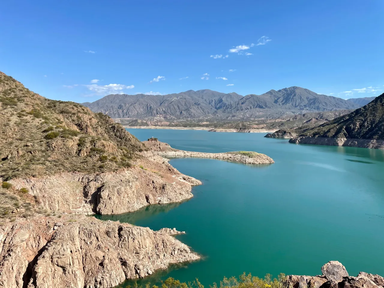
Potrerillos Reservoir and evidence of water emergency in Mendoza
My friend and I are both geographers, we studied most of our degree together, so when we are in environments like this, we can't help but analyze the landscape. And as you can see in the photos, beyond the beauty that can be seen between the mountains and the water, between the sky and the geoforms, there is a fairly wide line that runs along the foot of each hill.
You can see the green and then a light brown part that extends down to the water. That marks the water level that was there previously. This is quite unfortunate, as it means that the consecutive years of water emergency to which the province is exposed are leaving their serious consequences.
Just so you know a little of the history of this body of water, it is an artificial reservoir, created specifically to supply the population residing in the Greater Mendoza area, which is clearly increasing.
El Embalse Potrerillos y evidencias de la emergencia hídrica en Mendoza
Mi amiga y yo somos geógrafas, estudiamos gran parte de la carrera juntas, por lo que cuando estamos en entornos así, no podemos evitar analizar el paisaje. Y como pueden ver en las fotos, más allá de la belleza que se observa entre las montañas y el agua, entre el cielo y las geoformas, hay una línea bastante ancha qu recorre el pie de cada cerro.
Podrán ver el verde y luego una parte marrón clara que se extiende hasta llegar al agua. Eso marca el nivel de agua que había previamente. Es bastante lamentable esto, ya que esto significa que los años consecutivos de emergencia hídrica a los que está expuesta la provincia, están dejando sus serias consecuencias.
Para que sepan un poco de la historia de este cuerpo de agua, se trata de un embalse artificial, creado específicamente para abastecer a la población que reside en el Gran Mendoza y que va en claro aumento.


Why is this image so important for Mendoza?
Mendoza is a province with an arid climate, whose surface is largely a desert. In fact, its construction was possible thanks to the existing oases in the north, center and south (an oasis is a space where several rivers converge). The issue is that, over time, these rivers have been drying up.
This drought is due to the fact that Mendoza's rivers only receive water from snowmelt. That is to say, it snows in winter, in summer the snow melts, and that is the water we have.
The fact that the reservoir and the rivers are drying up is a consequence of a lower amount of snowfall (and of lower intensity), as well as an excessive use of water in the northern oasis in this case, because the Mendoza river feeds this oasis.
For this reason, the strip of soil that shows the drought is quite hard to see for a Mendoza local. But well, it is undeniable that the landscape is still beautiful.
¿Por qué es tan importante esa imagen para Mendoza?
Mendoza es una provincia de clima árido, cuya superficie constituye en gran parte un desierto. De hecho, fue posible su construcción gracias a los oasis existentes en el norte, centro y sur (un oasis es un espacio en donde confluyen varios ríos). El tema es que, con el tiempo, esos ríos se han ido secando.
Esta sequía se debe a que los ríos de Mendoza reciben únicamente agua del deshielo. Es decir, nieva en invierno, en verano la nieve se derrite, y esa es el agua que tenemos.
El hecho de que el embalse y los ríosse estén secando, es consecuencia de una menor cantidad de nevadas (y de menor intensidad), como también de un excesivo uso del agua en el oasis norte en este caso, porque el río Mendoza alimenta a este oasis.
Por ese motivo, la franja de suelo que deja en evidencia la sequía, es bastante fuerte de ver para un mendocino. Pero bueno, es innegable que el paisaje sigue siendo hermoso.

I hope you liked the publication and that in some way the data helped you to contextualize the landscape.
*The information provided in this publication does not have a specific source at this time, since it is what I studied at the university (Universidad Nacional de Cuyo), in the career of Professional Geographer.
Espero que les haa gustado la publicación y que de alguna manera los datos les hayan ayudado a contextualizar el paisaje.
La información brindada en esta publicación no tiene una fuente específica en este momento, ya que es lo que estudié en la universidad (Universidad Nacional de Cuyo), en la carrera de Geógrafo Profesional.
Pinmapple code: [//]:# (!pinmapple -32.99476 lat -69.14592 long Welcome to the magic of Argentina: walk with me through the Andes Mountains d3scr)

Device: iPhone 12 Pro
Translation: DeepL
Dispositivo: iPhone 12 Pro
Traducción: DeepL

