What's buzzin Hive!
HOT DAMN it's hotter than hell in Alberta! It reached almost 40 Celsius, 3rd highest ever recorded for my region. I never thought I would say this in the summer but how about some snow? LMFAO

The cats are just lumps of fur on the backyard cement pad in whatever shade they can find and they aint movin for nottin! Don't worry mum will bring us water, no need to get up! We had to go sit in the air conditioned truck for a few minutes before I became part of the sofa. While we were at it, we went for a little drive to the corner store. I stayed behind in the truck watching everyone walk out with their slurpies...Fantastic idea. Then I see this lady with something that looked like it was 2 litres of pure frozen sugary goodness. Normally I would be a little judgy in my own head thinking this is like a week's worth of sugar intake, how can anyone possibly survive drinking that but today was different...I found myself being a little jelly...perhaps it's big enough for me to bathe in it?


I'm glad we went on our hiking trip when we did and avoid physical exertion in such a scorcher. For whatever reason, people are still climbing mountains and there is an abundance of emergency calls to rescue heat stroked people off the mountains. Use common sense folks, seriously. It's hard to rescue people in the Rockies, try your best not to put yourself in such an awkward embarrassing situation like underestimating the heat in the middle of a province wide heat warning. We went on the solstice day so we got to enjoy the longest days of the year and you know me enough by now, I don't waste one daylight minute in the mountains no matter how I feel or temperature. I should probably start at the beginning but just because it's so hot , I'll start with the last day hike to Wilcox Pass overlooking the glaciers hoping it might cool me down in some sort of weird visual placebo effect.


Nestled in the heart of The Alberta Rockies, this hike was fairly close to our hotel with only a 50 km drive from Saskatchewan crossing and overlooks one of our favorite wonder, the Columbia Icefields. When I was doing my homework, I really had no idea what to expect as far as view, I just looked at how many kilometers we would be walking. To be honest good information was a little tough to find. I ended up climbing the darn mountain all the way to the ridge...Somehow my naïve mind assumed pass= nice flat field to cross between mountains. OOPSY! Boy was I wrong.


The trail head is near the Icefield interpretive center going towards Banff on the parkway, not difficult to find and well identified. Turns out it's also a pretty popular hike, I can see why! In other words, parking spaces are limited, arrive early to secure your spot or you may be stuck parking on the road. The hike to the official pass is about 335 meters (about 1100 feet) in elevation gain with a total of 9.3 km return hike. It's not an overly hard hike but it is challenging enough just the same, lets rate this a medium difficulty level. Don't bring grandma there but any adult with normal mobility and fitness should be able to handle this hike. Worst case scenario turn around after the first viewpoint if it's too difficult and it will still be well worth your while.


The mountain and pass gets it's name from one of the first recorded explorer to climb it in the late 1800's , Walter D. Wilcox, far from the first overall. Once upon a time, the Athabasca glacier was much larger and made access to the Sunwapta canyon difficult so Wilcox pass was used for regular travels to avoid the glacier. We will cover more about the glacier's history and melt patterns over the decades and even century in a later post to avoid making this post too long.


What should you bring? I would highly recommend bringing cleats if doing during the colder months or late spring/fall since even in almost July, we found quite a bit of snow still lingering on top especially on the way to the ridge and part of the trail are a bit on the edge at points. I went in my runners but a good pair of hiking boots isn't a bad idea . There is the obvious water, at least one to 2 bottles per person especially during summer. Doing this hike in June, it's less critical with all the snow melts and streams, there is some nice crisp mountain water to be had if you run out, it's some worthy #watertasting. Even in the summer, there is a river that runs around the halfway point.


We ate before the hike but didn't bring food and I kind of regretted it especially once I got to the top and was starving, a little advice, bring snacks for on top! Dress in layers, it goes from hot to cold to windy and back to scorching again all over the trail as some sections are pretty rocky and it's like walking thru an oven in some parts. For the same reason, a good hat and sunscreen is an asset, you will probably need to re-apply during the hike so take it with you. Bring some hiking poles, you will not regret it, certainly helps take pressure from old joints like mine!


As far as photography gear, to really maximize the photography experience, I would recommend the obvious landscape lens along with a 300 mm, you can get quite a close up of the glacier action on the mountains across the way. Not much for vegetation up there with a short growing season especially passed the tree line but there is a wide assortment of small wildflowers, having a macro lens available will add that much more. I had mine and didn't use it but that was more out of laziness than anything. There isn't much for wildlife or even food for them but it is Bighorn Sheep (Ram) territory along with birds and small animals like chipmunks and ground squirrel. Like anywhere in the Rockies, better bring bear spray. I forget to mention it sometimes but it's just good practice to always have it on a trail in bear country. Honestly, this is a busy enough trail that reduces the chance of an encounter.


Now that we are all packed, lets begin walking! The trail begins in the forest for the first km or so. This part is pretty steep and maybe a bit discouraging for my covid lungs but in the end, it was the whole point of this trip, to push ourselves and rebuild our lung capacity and stamina. The trail is pretty wide but also rough with tree roots exposed all along the way. They actually are more helpful than harmful as long as you lift your feet (I tend to trip on roots... well I trip on my own feet half the time). The roots help with soil erosion and it formed something like natural steps to climb on. Most hikes, we expect to mostly being the forest with few view points until reaching our destination. Not this one!


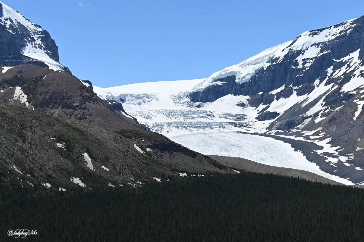
Pretty soon we found ourselves above the tree line and from there, you get a bit of a break from the steep trail for a little while. As the view opened up, we had a clear sight of all of the icefields and as we continued climbing, you get to stare at them at eye level along with all the fields and the road below. What an incredible view! Seeing them from up top is much different then from below, the detailing on the glacier ice is actually quite amazing. Also while coming out of the forest, I could smell all the wildflowers with what's left of my sense of smell (it never really came back after covid, only a little).

After the clearing, it keeps climbing a little but probably half of the elevation gain is in the tree portion of the hike. We continued our way up to the famous Parks Canada red chair viewpoint but just before we reached our anticipated rest stop, we met a young family and their (big) pup. The great part about hiking, everybody needs a break and making 15 minute friends on the trail is fairly easy. Everyone stopped for a little chat as their little girl want to show me her doggy. She was wearing a shirt with popsicles and ice cream logo and it was hot so she gave me a pretend popsicle from her shirt. I don't care how badass you are, if a little girl offers you a pretend popsicle on a trail during a hot day, YOU PRETEND EAT THAT THING! Thank you little girl, that is exactly what I needed, how refreshing...what a cutie! I know this irrelevant to the trail but she did make my day and I think vice versa.


We could hear some resonating crashing noises coming from all around us, loud too. It wasn't on our mountain and we were safe but glaciers were thawing along with this winter's snowfall across the way. As the snow melts, it becomes weaker and collapses under it's own weight then comes down in avalanches resonating along the mountain corridor. We heard this most of the hike, including a small rockslide on the mountain we were on (in a distance).This is where the 300mm comes in handy. We reached the coveted view point and red chairs, it was time to take a good long rest and enjoy the view, drink some water. This is by far the best view of the Columbia Icefields I have ever seen, including the time I was standing directly on the Athabasca Glacier. What a treat. If you don't feel as ambitious as we did, I highly recommend making it to this view point bare minimum if you are ever in the area and it doesn't take that long, maybe 2,5 km return trip for the view of a lifetime.


I had a feeling that what we were hearing was avalanches but after meeting 3 Parks Canada employees coming down from the mountain confirmed my suspicions and supposedly is very common for this hike to hear it all day long and we did! It was a first for me. Sitting in my comfortable red chair, I changed my lens and started observing the glaciers, really zooming in those avalanche zones. Both Dome and Andromeda glacier were cracking and falling simultaneously, Dome glacier was by far the most active that day.


Our break was long enough, it was time to get back on the trail. It levels off for a little while for a bit of relief but the climbing isn't over but half the elevation should be gained by then. The hills became more barren with the occasional wildflower patches growing here and there. We saw a river along the way, we didn't go down but it would be a good place for #watertesting. From this point, the trail seems to follow many edges. As we climbed, we could see the hill directly in front of us and the open view behind us. The true summit of Mount Wilcox also begins to be visible. With each hill that seemed large enough, we thought, we must be almost at our destination and ready to plant our proverbial flag , only to get up the hill to find ourselves at the bottom of another. Dear lord make that be the last one! Then again, and again...talk about discouraging!


Once we made to the top of many big hills, it leveled off again, maybe this time we had gained most of our elevation it felt like much more than 335 meters! As I mentioned earlier, there was still quite a bit of snow up there especially in the shaded areas sheltered from the sun by the ridge. We found ourselves in a wide open field with an incredible view of Nigel Peak that you simply don't see from the road, what a beauty. This is the one that had the rockslide on our way back down from the ridge.


For much of the "field" portion of the trail, the snow wasn't really an obstacle but became a point where a large stream from the melting snow cut across the field rushing down to the river, we did our water tasting from one of these springs. Yummy, somehow not as cold as I anticipated but there is still nothing like fresh mountain water. The stream wasn't overly deep, maybe a foot but it was wide enough that we would have to remove our shoes and socks to cut across. There are detours to avoid the water but why bother, it was mostly just wet everywhere. If you go barefoot, watch out for sharp rocks! It was actually quite refreshing to walk thru. At this point, it was mostly dirt and rocks and felt like being in a clay oven, wouldn't be shocked if I could fry an egg on them. It was around 25 degrees celcius, still a warm day overall.


This is where it gets weird for temperature, baking on the rocks and freezing on the snow all at the same time. In no time, we had reached our destination...Wilcox pass at last! Then the sign pointed to a fork in the trail, either continue 1.4 km to the ridge or go a few km further to the true summit. Well we made it this far, what's another 1.4 km! Easier said than done. This area was really shaded and still had a few feet of snow to cross thru and climbing another series of this is the last hill. Not again! To top it off, it was extremely windy the closer we climbed to the ridge and it actually became quite cold suddenly.


Each hill had it's own snowbank to cross. Luckily the snow was still somewhat solid (sort of) and we didn't sink much more than a foot deep. We saw this curious rock half fort wall, perhaps was built as a windbreak by hikers? I'm not sure what I was looking at to be honest. By this time, it was nearly impossible to distinguish the trail in the rocks or where to go next. Just completely barren up there. Every so often, there is some rock piles with a yellow tag on them, that is the trail marker when it just disappears, follow the yellow tags and you wont get lost. It's a bit overwhelming finding your way without them.


We knew we had to be close, we found ourselves making our way to what we thought was the last hill. Son of a bitch! All we found was another darn hill! Only this one, there was still 6 feet of snow to climb thru to get to the official ridge. Hell NO! This was ridge enough for me. We didn't get to the final view of the bottom but to be honest, nothin about this hike was disappointing even if we didn't get to see the top glacier view below, we still had an incredible view of them for the entire trail especially on the way back down. I'm sure we didn't rally miss out that much in the end. We probably missed an incredible view of The Sunwapta valley since that part was blocked by all the last hills we climbed :D


Now the other trail, it's still doesn't seem too terrible and I might want to add it to my bucket list but this one requires a bit more advanced planning. Bring food! It will be a bit more challenging and calorie consuming but i's a very realistic hike. Having 2 vehicles, one parked at the near-by Tangle Creek falls, it's an 11 km hike total. Obviously a return hike would be a bit much for most people at 22 km but not impossible. This was probably one of my favorite hikes ever taken, I want to do it again. Maybe next time I can go in the month of August, maybe there will be less snow!


We felt pretty accomplished. After our covid/pneumonia, it left us all messed up and struggling with physical exertion along with much reduced lung capacity. On top of that, so high up in the Rockies before we even begin the climb, the air tends to get thinner and breathing naturally becomes more difficult even for a healthy person. The first day, I almost passed out on a half hour flat walk across a field, here I was 4 days later climbed to the ridge of a mountain! I did take a lot of breaks tho, took us 2 hours longer than it should have but we made it. Incredible muscle pain/cramps is another side effect I was left with. It's been like 4 days and I'm only starting to walk normal again today but no pain no gain! Oh and I'm still all sunburned from baking in the rocks and I was wearing sunscreen. We walked in all seasons in one day...pretty incredible.

The way down was much of the same, the only difference was when we were in the forested portion of the hike, we found a grouse. That mountain chicken is lucky we were in a national park. Given how hungry I was, the entire time I was taking pictures of it, it didn't look like an animal anymore, I could picture smelling it cooking on the BBQ...Maybe I should have some food soon...not to worry, we had stale bread sandwiches waiting for us.


What's near-by for amenities? Not much to be honest. There is a Starbucks open until 5 in the icefields information center...that's pretty much it, your mostly left to your own device in that section so get all your needs for the day/week met before leaving a townsite. Not much for cell reception either, only at the red chairs coming from the Information center that's pretty much it until near Banff, Lake Louise or Jasper ( few hours drive from there). We didn't go to town much, only once, all our supplies came with us from Edmonton before we left knowing how remote this entire trip would be. Saskatchewan Crossing is about 50 km away and has minimal supplies and a restaurant but it's incredibly pricy due to the remote nature. This is long enough for now...Cheers my friends! xox
All images taken with Nikon Z6