The next morning I got up at sunrise even though I was in the middle of the woods and I didn't have to see him anywhere. But somehow I knew it was a long day ahead. The first task of the day was to replenish water supplies and so I found where the first store is on the way.
Druhý den ráno jsem vstal na východ slunce i když jsem byl uprostřed lesů a neměl jsem šanci ho kdekoliv vidět. Ale tak nějak jsem tušil, že je přede mnou dlouhý den. První úkol dne byl doplnit zásoby vody a tak jsem si našel kde je první obchod po cestě.

On the way to the store, I met this modern clear sign. Little did I know that this was the last I saw. Before the store, I had an interview with a lady who asked where I was going from and where I slept. When I told her that in the woods in a tent, so he just asked if my food did not try to get the foxes.
Cestou do obchodu jsem potkal tuto moderní přehlednou ceduli. To jsem netušil, že je poslední kterou vidím. Před obchodem jsem měl rozhovor s paní, která se vyptávala odkud jdu a kde jsem spal. Když jsem jí řekl, že v lese ve stanu, tak se hned ptala jestli se mému k jídlu nesnažili dostat lišky.

I continued across the field when I saw the first view of the Alps, where I thought I was heading. I estimated the way for the next day. I was wrong, it lasted longer, but more on that later.
Dále jsem pokračoval přes pole, když jsem viděl první pohled na Alpy, kam jsem si myslel, že směřuji. Odhadoval jsem cestu tak na další den. Mýlil jsem se, trvalo to déle, ale o tom později.

Across the forest, where I experienced the first small wandering, caused by the fact that the survey signs are marked in the same way as the hiking trail. Fortunately, I noticed it early and I didn't even go too far for about 500 meters. I arrived near a village called Bromberg, where I was fascinated by a special nature trail that focused on the history of witchcraft.
Přes les jsem, kde jsem zažil první malé bloudění, způsobené tím, že zeměměřičské značky jsou značeny stejně jako turistická stezka. Naštěstí jsem si toho všiml brzy a ani jsem si moc nezašel cca 500 metrů. Dorazil jsem nedaleko vesnice s názvem Bromberg, kde mě zaujala jedna speciální naučná stezka, která byla zaměřena na historii čarodejnictví.

Then somehow the road quickly passed through forests and meadows and the evening was slowly approaching. Looking at the weather, I found that strong storms were approaching from the west. So I looked at the map, where it would be ideal to survive this. I found a large number of caves on the map near the town of Scheiblingkirchen, so I decided to explore whether one could spend the night in one.
Pak nějak cesta rychle přes lesy a louky utekla a pomalu se blížil večer. Při pohledu na počasí jsem zjistil, že od západu se blíží silné bouřky. Podíval jsem se tedy do mapy, kde by bylo ideální toto přežít. Našel jsem v mapě poblíž městečka Scheiblingkirchen velké množství jeskyní, tak jsem se rozhodl prozkoumat zda by se v některé nedala strávit noc.

I found one perfect. Due to the fact that there are many climbing routes on the local rocks, this cave is inhabited quite often. The storm was approaching and I knew I would spend the night dry without having to pitch a tent.
Jednu ideální jsem našel. Vzhledem k tomu že je zde mnoho horolezeckých cest na zdejších skalách, bývá tato jeskyně obydlena poměrně často. Bouřka se blížila a já jsem věděl, že přežiji noc v suchu bez nutnosti stavět stan.
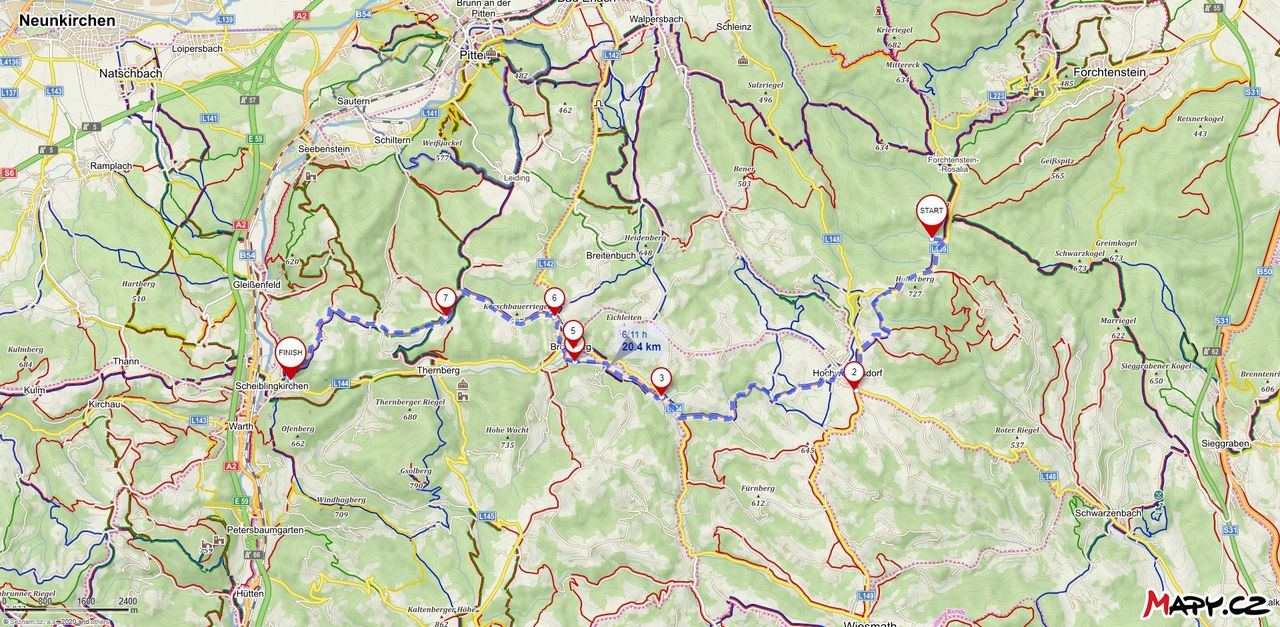
The next day I added a little and I covered 20.4 km with an altitude of almost 1000 meters. Although most of the way was downhill. Exactly 615 meters down and 336 meters uphill.
Druhý den jsem trošku přidal a urazil jsem 20.4 km s překonáním nadmořské výšky skoro 1000 metrů. I když většina cesty byla z kopce. Přesně 615 metrů dolů a 336 metrů do kopce.